 Bac Tu Liem
  Cửa Lò
  Tuy Hòa
  Đông Hà
  Viet Tri
  Quảng Ngãi
  Tam Kỳ
  Krông Pắc
  Vân Đồn District
Công viên Sông Hậu on the map, Can Tho, Vietnam
Photo

Where is located Công viên Sông Hậu
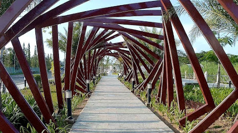
Công viên Sông Hậu — local attraction, which is located at 2QXR+Q95, Cái Khế, Ninh Kiều, Cần Thơ, Vietnam and belongs to the category — park. Average visitor rating for this place — 4.3 (according to 1720 ratings, information from open sources and relevant for 2022).
Exact location — Công viên Sông Hậu, marked on the map with a red marker.
You can get directions to Công viên Sông Hậu on the map from your location.
What else is interesting in Can Tho? You can see all the sights if you go to the city page.
Coordinates
Công viên Sông Hậu, Vietnam coordinates in decimal format: latitude — 10.049330553773393, longitude — 105.79092842434407. When converted to degrees, minutes, seconds Công viên Sông Hậu has the following coordinates: 10°2′57.59 north latitude and 105°47′27.34 east longitude.
Nearby cities
The largest cities that are located nearby:
- Cà Mau — 116 km
- Bien Hoa — 156 km
- Vung Tau — 156 km
- Phnom Penh
(Cambodia) — 190 km
- Phan Thiet — 274 km
- Buon Ma Thuot — 381 km
- Siem Reap
(Cambodia) — 420 km
- Cam Ranh — 421 km
- Krong Battambang
(Cambodia) — 435 km
- Nha Trang — 445 km
- Qui Nhơn — 557 km
- Rayong
(Thailand) — 563 km
- Kota Bharu
(Malaysia) — 578 km
- Ubon Ratchathani
(Thailand) — 583 km
- Kuala Terengganu
(Malaysia) — 595 km
- Si Racha
(Thailand) — 624 km
- Hat Yai
(Thailand) — 669 km
- Bangkok
(Thailand) — 697 km
- Pak Kret
(Thailand) — 703 km
Distance to the capital
Distance to the capital (Hanoi) is about — 1221 km.
